
Analysis based on an investigation by Radio Liberty’s Belarusian service, materials from a joint cyber operation by the Fenix analytical center and InformNapalm volunteer intelligence community, satellite images from Planet Labs cited in the Radio Liberty study, and data from Ukrainian and international OSINT monitoring communities.
Background
Russia has established a distributed drone warfare infrastructure along the Belarusian border. This involves at least five airfields and launch complexes in the Smolensk, Bryansk and Oryol regions, routing attack UAVs along or through Belarusian airspace and using Belarusian civilian communications infrastructure to support routes and signals.
This system is not only being used against Ukraine. In September 2025, according to the findings of the joint cyber operation by Fenix and InformNapalm, the incursion of dozens of Russian drones into Poland was part of testing new tactics and the capabilities of Belarusian mobile operator infrastructure. On February 18, 2026, Ukraine imposed sanctions against Alexander Lukashenko. Among the grounds cited was the deployment in Belarus of infrastructure that enhanced the capabilities of Russian drone attacks.
On June 10, 2026, Radio Free Europe’s Belarusian service published an investigation identifying key Russian military facilities near the Belarusian border. This data is important not only for recording Russian military infrastructure. It provides a better understanding of the threat architecture: where Russia is stockpiling UAVs, from where it launches them, what routes they might use, why drones regularly enter Belarus, and how this territory is becoming part of the operational geography of Russia’s war against Ukraine.
Five key facilities
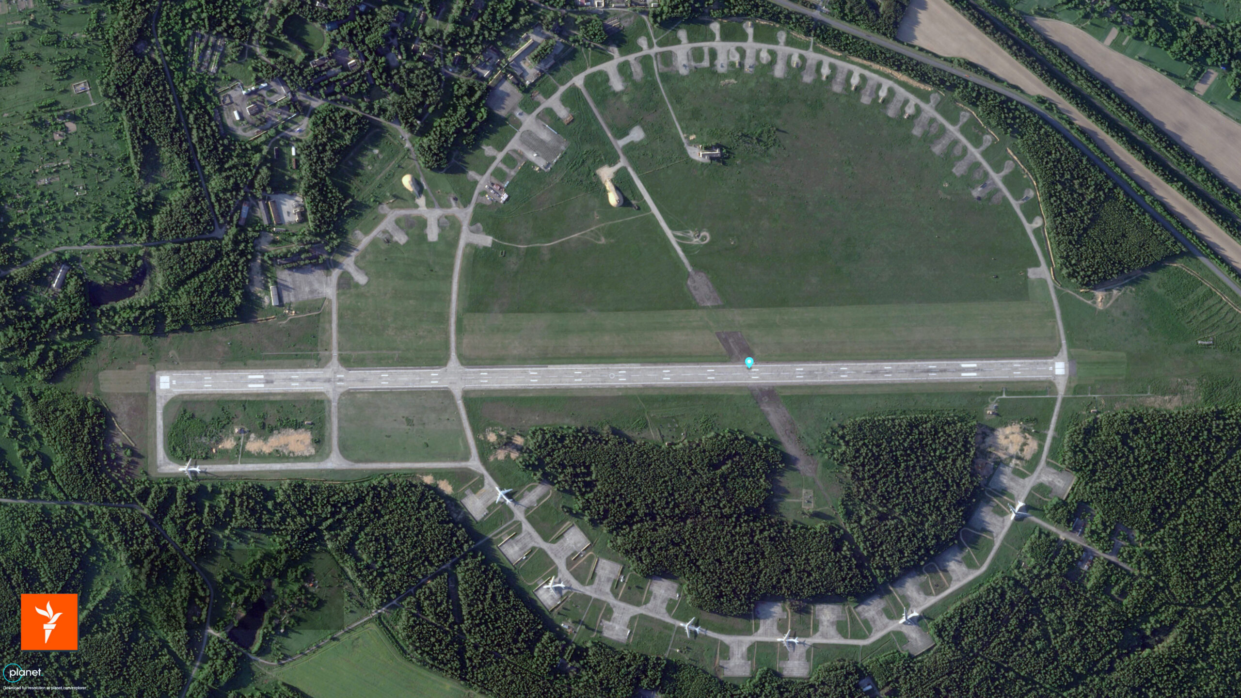
1. Shatalovo Airfield, Smolensk Oblast
Coordinates: 54.33892, 32.47221
Distance to the border with Belarus: about 46 km Status: in use since early 2025
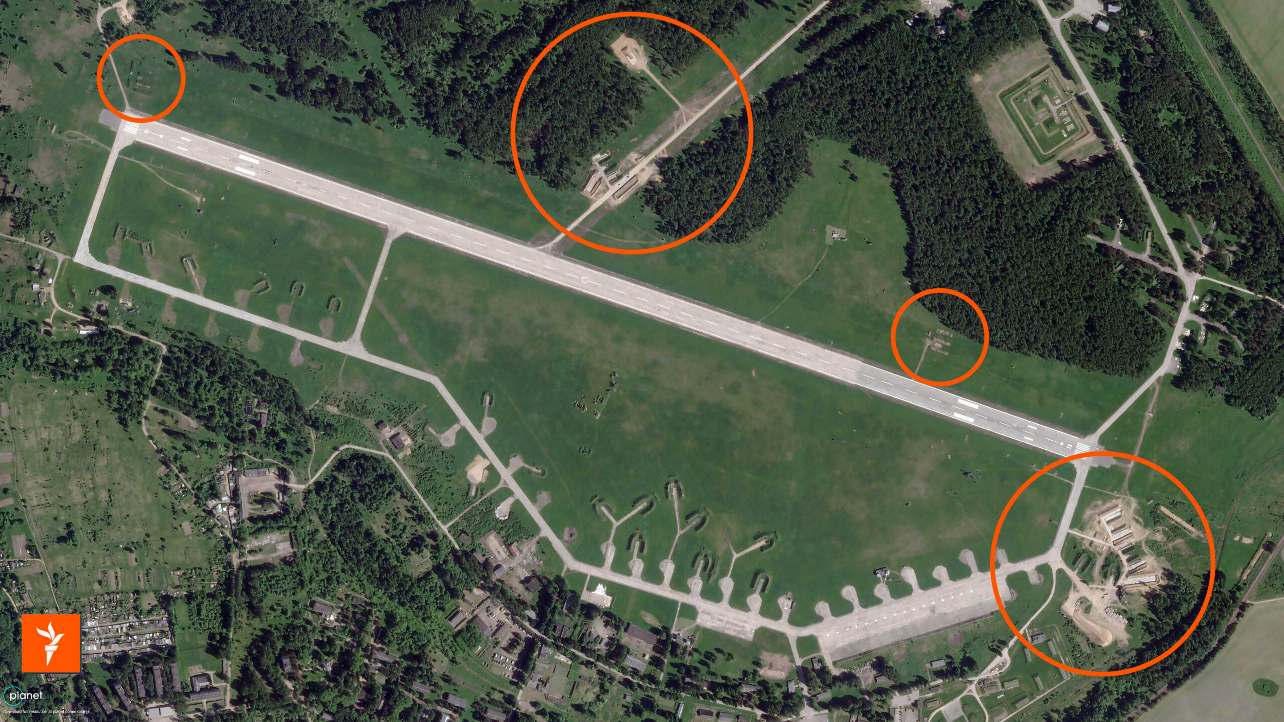
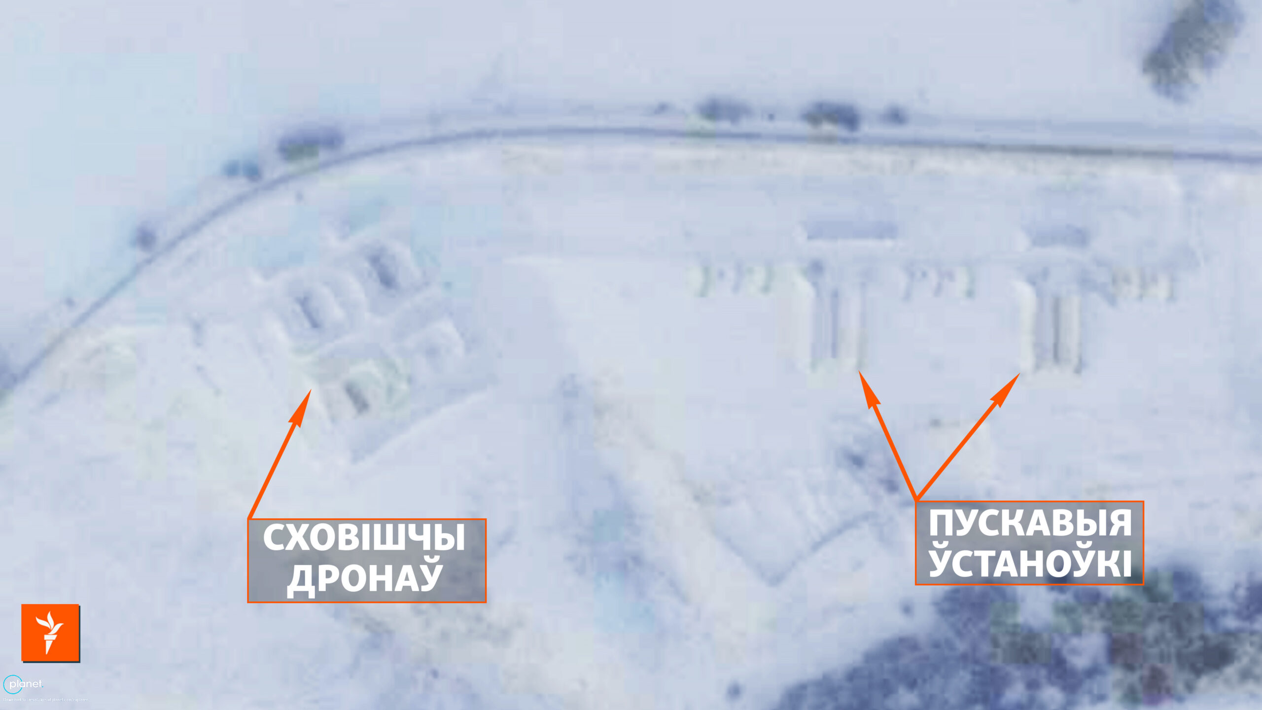
Shatalovo is the closest known Russian launch site for attack drones to Belarus. Construction work at the airfield began in early 2025. Almost immediately, two stationary launchers for Shahed/Geran drones appeared in the eastern part of the facility. A Planet Labs satellite image from May 5, 2026, shows about ten such launchers, and ongoing construction.
Air defense systems and probable shelters for drones have also been observed at the site. According to Ukrainian monitoring channels, launches from Shatalovo may occur several times a week.
Another important indication is the traces of possible launches of jet-powered variants of the Geran. A photo taken on March 1, 2026, black marks are visible in the snow near the launchers, resembling the aftermath of jet engine operation. This suggests that Shatalovo may not only be a launch site for conventional piston-powered strike drones but also part of Russia’s transition to faster jet-powered variants.
In September 2025, Shatalovo was mentioned as one of the launch points for drones that flew into Poland. This takes the facility beyond the scope of the purely Ukrainian theater of operations and makes it part of a broader threat to NATO’s eastern flank.
2. Tsimbulova launch complex, Oryol Oblast
Coordinates: 53.36858, 35.81660
Distance to the border with Belarus: about 200 km
Status: in use since autumn 2024
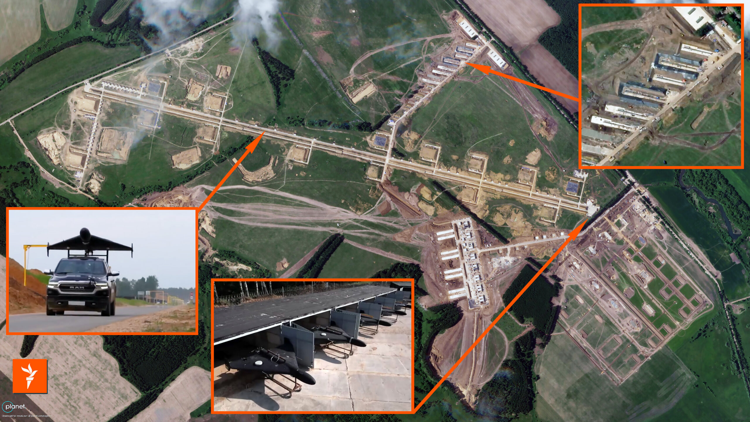
The complex near Tsimbulova is one of the most well-known Russian launch sites for attack UAVs. Construction began in August 2024, and the first launches may have taken place in the fall of that same year.
According to a Planet Labs satellite image from June 1, 2026, the facility covers an area of nearly 2 by 4 km. Over the spring of 2026, the complex nearly doubled in size. At least 12 operational launchers are visible on the site, and up to eight additional stationary positions may be preparing for commissioning. A long launch strip for launches from vehicle platforms and about a hundred storage and support structures were also identified.
According to estimates by Ukrainian researchers, hundreds of attack drones can be stored at this site at a time. This is why Tsimbulova should be viewed not merely as a launch point, but as a major rear drone hub—a site for build-up, preparation, logistics, and mass launches.
A particularly alarming detail is the long rail launchers, approximately 85 meters long, which analysts link to preparations for the launch of new jet-powered versions of the Geran drone, specifically the Geran-5. If this assessment is confirmed by further monitoring, Tsimbulova becomes an indicator of the technological evolution of Russia’s drone campaign: from slow loitering munitions to faster pseudo-cruise missiles that are more difficult to intercept.
3. Launch complex near Navlya, Bryansk Oblast
Coordinates: 52.85476, 34.50651
Distance to the border with Belarus: approximately 127 km.
Distance to the border with Ukraine: approximately 75 km
Status: in use since fall 2024.
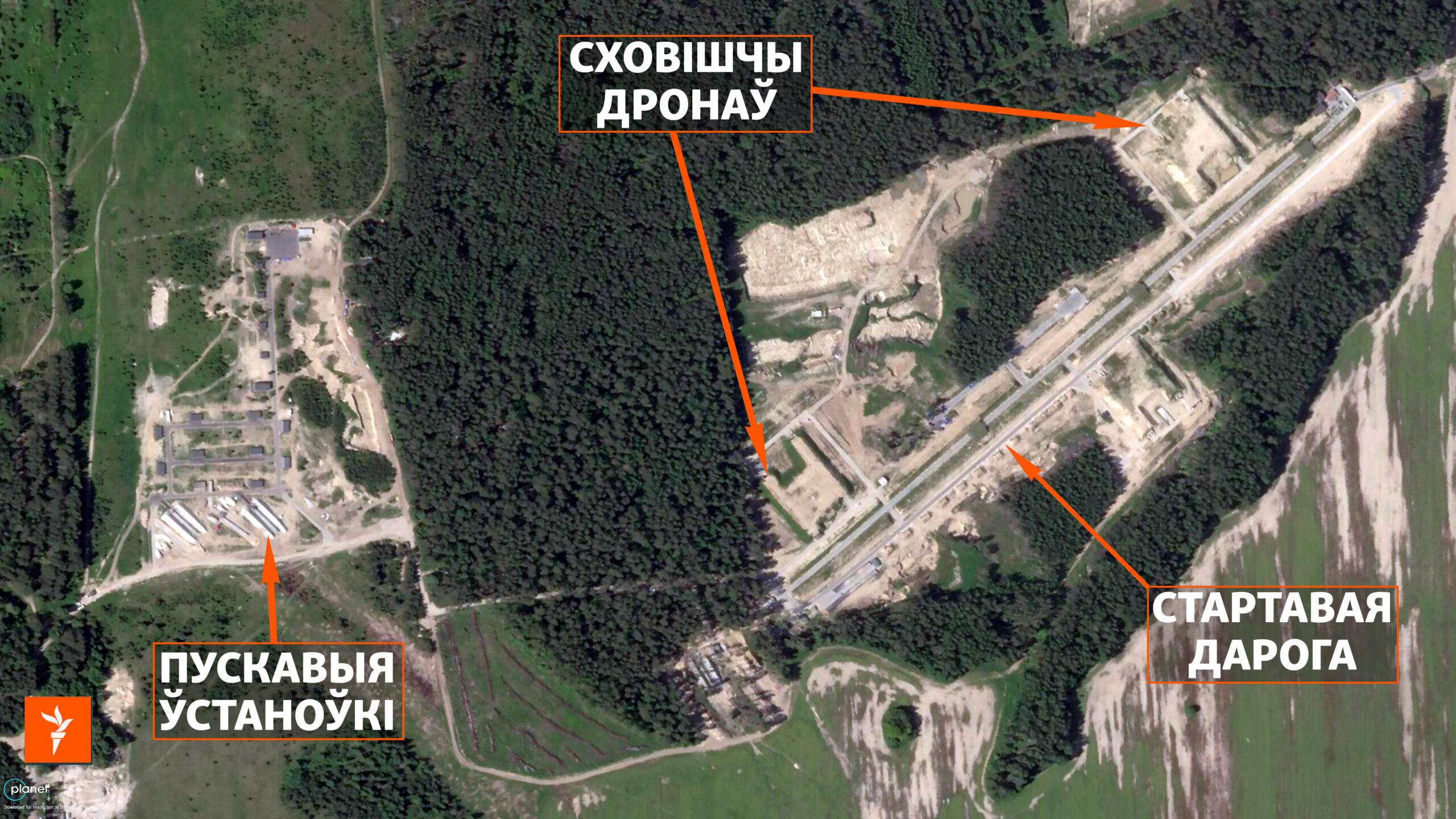
The complex near Navlya was built from scratch. As recently as 2022, there was nothing at this site except a dirt road. Active construction began in the summer of 2024: first, a strip for launching drones from vehicle platforms, as well as three large storage earth-covered arch bunkers were built.
In 2025, the facility was expanded. A photo from June 1, 2026, shows at least three stationary launch positions and about 16 small protected shelters, presumably intended for storing UAVs. Construction work at the facility continues.
In April 2026, the Ukrainian Defense Forces carried out strikes on the complex near Navlya. However, according to monitoring channels, the facility continued to launch Geran strike drones and Gerbera decoy drones several times a week, including on June 1 and 3, 2026.
This case is important for understanding the resilience of Russian drone infrastructure. Dispersed field complexes with shelters, launch pads, and multiple positions are capable of quickly resuming operations after strikes. Therefore, neutralizing such facilities requires not a single strike, but systematic monitoring, repeated verification of their status, and assessment of their recovery rates.
4. Seshcha Airfield, Bryansk Oblast
Coordinates: 53.71538, 33.34548
Distance to the border with Belarus: approximately 45 km
Status: in 2023, it was listed as one of the launch sites; from 2022 to 2024, it served as a transit hub.
The logic behind Seshcha is somewhat different from that of the new field complexes. This is not a new site, but a military airfield that served as one of the key transit hubs for Russian military aviation operations between Russia and Belarus from 2022 to 2024.
In 2023, Ukrainian Air Force spokesperson Yurii Ihnat identified Seshcha as one of the main launch sites for Russian Shaheds heading toward Kyiv. British military intelligence also noted this role. Following the Ukrainian drone strike on Seshcha in May 2023, the airfield largely disappeared from Ukrainian public reporting as an active launch site for strike drones.
However, the facility has not lost its significance. Satellite images from June 4, 2026, show new construction work, earthworks for the deployment of air defense systems, the dispersal of transport aircraft, and the partial covering of aircraft with car tires as improvised protection against drones.
Seshcha remains an important logistics hub and a potential point for future reactivation. Its significance lies not only in its potential for future launches but also in its role within the broader northern infrastructure arc of Russia’s invasion of Ukraine — supporting cargo transport, aircraft dispersal, facility protection, and military logistics along the Belarusian axis.
5. Launch complex near Asovitsa, Bryansk Oblast
Coordinates: 52.32268, 34.50236
Distance to the border with Belarus: approximately 163 km.
Distance to the border with Ukraine: approximately 35 km
Status: new facility in the deployment phase; operations could begin several months after construction start.
Asovitsa is the newest of the recorded facilities in this belt. Construction began in the summer of 2025. A Planet Labs satellite image from January 11, 2026, shows at least two stationary launch pads and four small fortified storage facilities.
Formally, investigators assume that this facility could have been used for launches as early as a few months after construction began. At the same time, it is more accurate to view Asovitsa as a facility under development, rather than as a fully formed complex on a par with Tsimbulova or Navlya.
This is precisely why Asovitsa has special analytical value. It demonstrates what the early development phase of Russian launch infrastructure looks like: the construction of launch pads, shelters, access roads, fortified storage facilities, and the gradual transformation of an empty plot into a military site.
Its location approximately 35 km from the Ukrainian border radically reduces flight time to the northern regions of Ukraine. If fully operational, this facility could heighten the threat to the Chernihiv, Sumy, and Kyiv Oblasts, as well as transport routes along the Russian-Ukrainian border.
Scale context
According to Ukraine’s General Staff, Russia operates at least 14 known strike drone launch sites across its territory. In addition to sites near Belarus, the list includes Oryol, Khalino, Millerovo, Donetsk, Yeisk, Primorsko-Akhtarsk, the Chauda training range, Gvardeyskoye, and Berdyansk.
The belt along Belarus is one of the most dynamic segments of this system. Its distinctive feature is a combination of proximity to the Ukrainian capital, the ability to trace routes along the Belarusian border, the proximity of Belarusian airspace as a zone of political uncertainty, and the potential to utilize Belarusian civilian communications infrastructure.
Belarusian corridor not a “cross-border area,” but part of the theater of operations
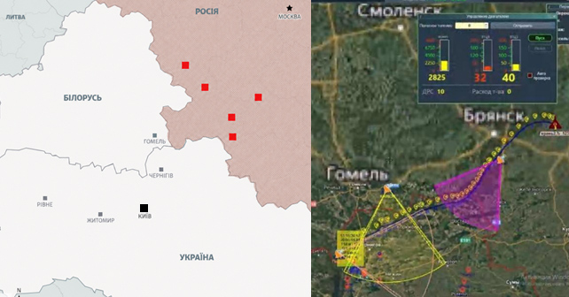
The first mass incursions of Russian drones into Belarus were recorded in July 2024. This coincided with the deployment of large launch complexes in the Bryansk, Oryol, and Smolensk oblasts of the Russian Federation.
Since then, the Belarusian axis has been increasingly used as a corridor or borderline maneuvering zone for Shahed / Geran attack drones and Gerbera decoy drones. Some of the drones enter Belarusian airspace, while others skirt the Belarusian-Ukrainian border before heading inland toward the Kyiv, Zhytomyr, or western oblasts of Ukraine.
Even Belarusian officials acknowledge the scale of the problem. According to Andrei Lukyanovich, commander of the Belarusian Air Force and Air Defense, more than 1,400 airspace violations were recorded in 2025 alone. Nikolai Karpenkov, Commander of the Internal Troops, stated that in 2025, approximately 520 drones were neutralized or defused after crashing on Belarusian territory, a third of which were combat drones. In 2026, Belarusian security forces acknowledged for the first time that such incursions occur almost daily.
At the same time, official Minsk systematically avoids any direct acknowledgment of the Russian origin of these drones. Their attribution is either not specified or is presented as “Ukrainian.” This information tactic allows the Lukashenko regime to smokescreen the obvious: Belarus does not have full control over its own airspace and is effectively allowing Russia to use it as in the war against Ukraine.
The Ukrainian military has identified a tactical pattern where Russian drones “hug” the Belarusian border. This complicates the work of Ukrainian air defense forces and mobile fire groups, as the use of firepower in close proximity to the border with Belarus is subject to political and operational restrictions. This Russia, creates a safer zone of maneuver by blending military logic with political blackmail.
Signal relay: the role of Belarusian civilian infrastructure
A separate layer of this system involves signal transmission, routing, and relay. Precisely this aspect that was documented during a cyber operation by the Fenix analytical cyber center, with support from InformNapalm volunteer intelligence community.
In February 2026, InformNapalm published the findings of this operation. For more than six months, Ukrainian cyber specialists covertly monitored the activities of Russian strike drone operators. They gained access to the accounts of dozens of Russian military personnel and to the monitoring systems used by drone operators. This allowed the Ukrainian Defense Forces to receive data on UAV flight paths, mission objectives, and specific elements of the Russian command-and-control system.


Key finding of the operation: Russia actively used Belarusian civilian infrastructure, specifically mobile operator towers, to plot routes for its drones and maintain a stable signal. This expanded Russia’s ability to strike the northern regions of Ukraine, from Kyiv to Volyn.
As of September 2025, intercepted data from Russian operators featured routes running along the inner side of the Belarusian border. That same month, operational intelligence shared with NATO partners indicated that the entry of dozens of Russian drones into Polish airspace on the night of September 9–10, 2025 was not accidental — but a deliberate test of new routing tactics and the signal relay capabilities of Belarusian civilian telecommunications infrastructure.
This episode is critically important. It shows that Belarusian infrastructure is being used not only for strikes against Ukraine. It may be part of preparations for broader scenarios targeting NATO logistics, in particular on supply routes for weapons, equipment, and ammunition carried to Ukraine.
System Architecture: Four Circuits of Russia’s Drone Warfare
Shatalovo, Tsimbulova, Navlya, Seshcha, and Asovitsa viewed as isolated points is missing the bigger picture. We are looking at a cohesive architecture consisting of at least four components.
- The first component is the launch. There are stationary launchers, launch runways, vehicle platforms, rail launchers for rocket variants, and prepared positions for massed launches.
- The second component is storage and logistics. There are fortified storage facilities, bunkers, auxiliary structures, transport hubs, airfields, and sites capable of holding hundreds of strike drones.
- The third component is route tracing. This involves the use of airspace near Belarus, movement along the border, incursions into Belarusian airspace, and subsequent heading changes deep into Ukraine.
- The fourth component is control and relay. This includes communication channels, mobile operator towers, repeaters, and digital infrastructure that maintains en-route connection stability and enhances drone effectiveness.
The very combination of these four components makes the Russian drone threat more persistent. If one element is destroyed or damaged, the system can temporarily redistribute the traffic to other assets. If one route becomes risky, the Russians test others.
If classic Shahed drones become less effective, the infrastructure is adapted for jet-powered variants and decoy drones.
Russia’s operational logic
Russia has several key objectives in maintaining the Belarusian corridor.
- First is the route variability. Launches from different regions allow them to strain Ukrainian air defense in multiple directions simultaneously and make trajectory prediction more difficult.
- Second is the reduction of flight time to Kyiv and the northern oblasts of Ukraine. Shatalovo and Seshcha are significant for the Kyiv direction; Navlya and Asovitsa are important for the Chernihiv, Sumy, and Kyiv oblasts; and Tsimbulova serves as a major rear hub for mass launches on a wide range of routes.
- Third is taking advantage of Belarusian airspace as a politically complicated zone for Ukrainian countermeasures. Russia is aiming to create a situation where the military necessity of intercepting a drone clashes with the risk of political escalation on the Belarusian front.
- Fourth is system resilience. Navlya demonstrates that launches can quickly resume even after strikes on the complex. For Russia, this means that a dispersed field infrastructure may be more effective than a single large and vulnerable hub.
- Fifth is buildup. Rail launchers at Tsimbulova and traces of probable jet-powered launches at Shatalovo indicate that Russia is not winding down its drone campaign but upgrading it — with the ultimate objective of terrorizing Ukraine’s civilian population.
How this data helps pinpoint threats
The coordinates of launch complexes and airfields are of practical value to OSINT communities, monitoring projects, security agencies, and early warning systems. This is the foundation of situational awareness.
- Mapping launch areas.
Having precise coordinates allows us to map potential launch areas and compare them with the actual drone routes during large-scale attacks. If UAV movement is detected on a given night across southeastern Belarus or along the Belarusian border, it can be connected with possible launch areas: Shatalovo, Seshcha, Navlya, Asovitsa, or Tsimbulova. - Identifying corridors.
Comparing launch areas with drone flight paths, points of entry into Belarus, mobile network coverage zones, and likely relay stations helps identify recurring corridors. Identifying such corridors may be more important than catching individual launches, as they reveal exactly where Russia is testing established routes. - Monitoring signs of attack preparations.
Regular satellite monitoring allows for the detection of predictors of future activity: the appearance of equipment, the expansion of storage facilities, changes in the configuration of launch positions, the construction of new roads, the appearance of air defense systems, the camouflaging of aircraft, or an increase in the number of shelters. - Identifying new facilities at an early stage.
The Asovitsa case study shows that new launch complexes can be documented even before they are fully operational. For OSINT, this means the need to monitor not only known airfields but also field sites with specific features: launch roads, shelters, bunkers, earthworks, access roads, and security infrastructure. - Assessing the resilience of facilities.
Open-source data indicates that the facility continued to be used after the strikes on Navlya. This means that the assessment of the effectiveness of the strike must be based not only on the fact of the strike as such, but also on subsequent monitoring: equipment moving in, launches resuming, shelters being repaired, site’s configuration being changed. - NATO dimension.
The Polish incident on September 9–10, 2025, demonstrated that this infrastructure is now significant not only for Ukraine. Routes passing through or along Belarus can be used as a tool to project pressure on Poland, the Baltic states, and the logistics routes for aid deliveries to Ukraine. Therefore, monitoring this corridor is in the common interest of Ukraine, Poland, Lithuania, Latvia, Estonia, and NATO as a whole.
Minsk’s Political Responsibility
The Belarusian regime is attempting keep a foot in two camps. On the one hand, it acknowledges mass airspace violations, the downing of drones, and the need to neutralize them. On the other hand, it avoids attributing these drones to Russia, and continues to provide political cover for the aggressor.
But the reality is different. If Belarusian territory is being used to route Russian drones, if its airspace is becoming a corridor for strikes against Ukraine, and if civilian telecommunications infrastructure is being used to support the signal transmission, then Minsk cannot be considered a neutral observer.
The Belarusian regime is not merely a political ally of Russia. It has turned the country into an infrastructural appendage of the Russian war machine. And that is precisely why sanctions against Lukashenko for his role in escalating the drone war have a factual, rather than merely symbolic, basis.
Conclusion
Russia has deployed a drone belt along the Belarusian border, comprising launch complexes, airfields, storage facilities, logistics hubs, border routes, the use of Belarusian airspace, and signal relay elements via Belarus’s civilian telecom infrastructure.
Its purpose is to increase the scale, versatility, and survivability of Russian drone attacks; reduce flight time to Ukraine’s northern regions; complicate the work of air defense systems; use Belarus as a zone of political cover; and test scenarios for applying pressure on NATO’s eastern flank.
For Ukraine, OSINT communities, and NATO partners, the task is not merely to record individual launches. It is necessary to map the entire architecture: launch sites, storage facilities, logistics hubs, routes, relay stations, signal coverage zones, and recurring flight corridors.
The Belarusian direction is one of the key elements of Russia’s drone war against Ukraine and a potential security threat to the broader region in Europe.
This analysis based on open-source data was prepared by Roman Burko, founder of InformNapalm international volunteer intelligence community.
![]() Compiled specially for InformNapalm readership. Distribution and reprint with reference to the source is welcome! (Creative Commons — Attribution 4.0 International — CC BY 4.0). Subscribe to InformNapalm social media pages.
Compiled specially for InformNapalm readership. Distribution and reprint with reference to the source is welcome! (Creative Commons — Attribution 4.0 International — CC BY 4.0). Subscribe to InformNapalm social media pages.
![]() InformNapalm does not receive any financial support from any country’s government or large donors. Only community volunteers and our readers help us to maintain the site. You can also become one of the community volunteers or support InformNapalm with your donations.
InformNapalm does not receive any financial support from any country’s government or large donors. Only community volunteers and our readers help us to maintain the site. You can also become one of the community volunteers or support InformNapalm with your donations.


No Responses to “A drone belt along Belarus border: Russia developing infrastructure for the launch, tracking, and relay of attack UAVs”